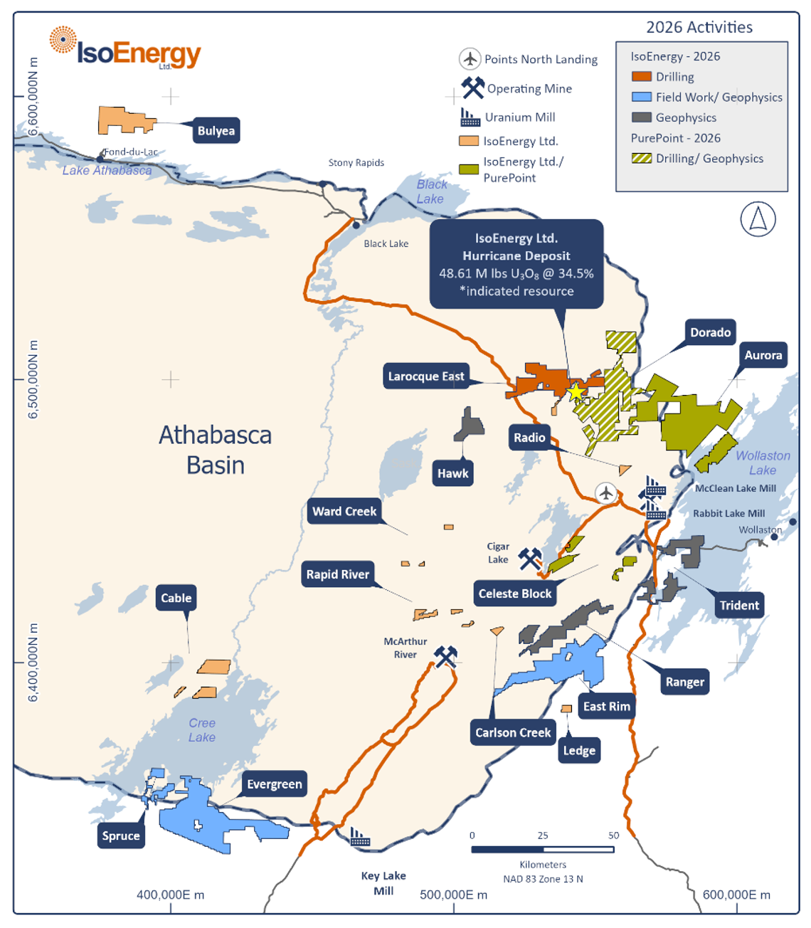
PUREPOINT URANIUM JOINT VENTURE
The Joint Venture spans over 98,000 hectares and consolidates 10 high-valued uranium projects into three distinctive areas in Saskatchewan’s eastern Athabasca Basin: the Dorado Project, the Aurora Project and the Celeste Block.
IsoEnergy and Purepoint Uranium Joint Venture including, Dorado Project, Aurora Project and Celeste Block
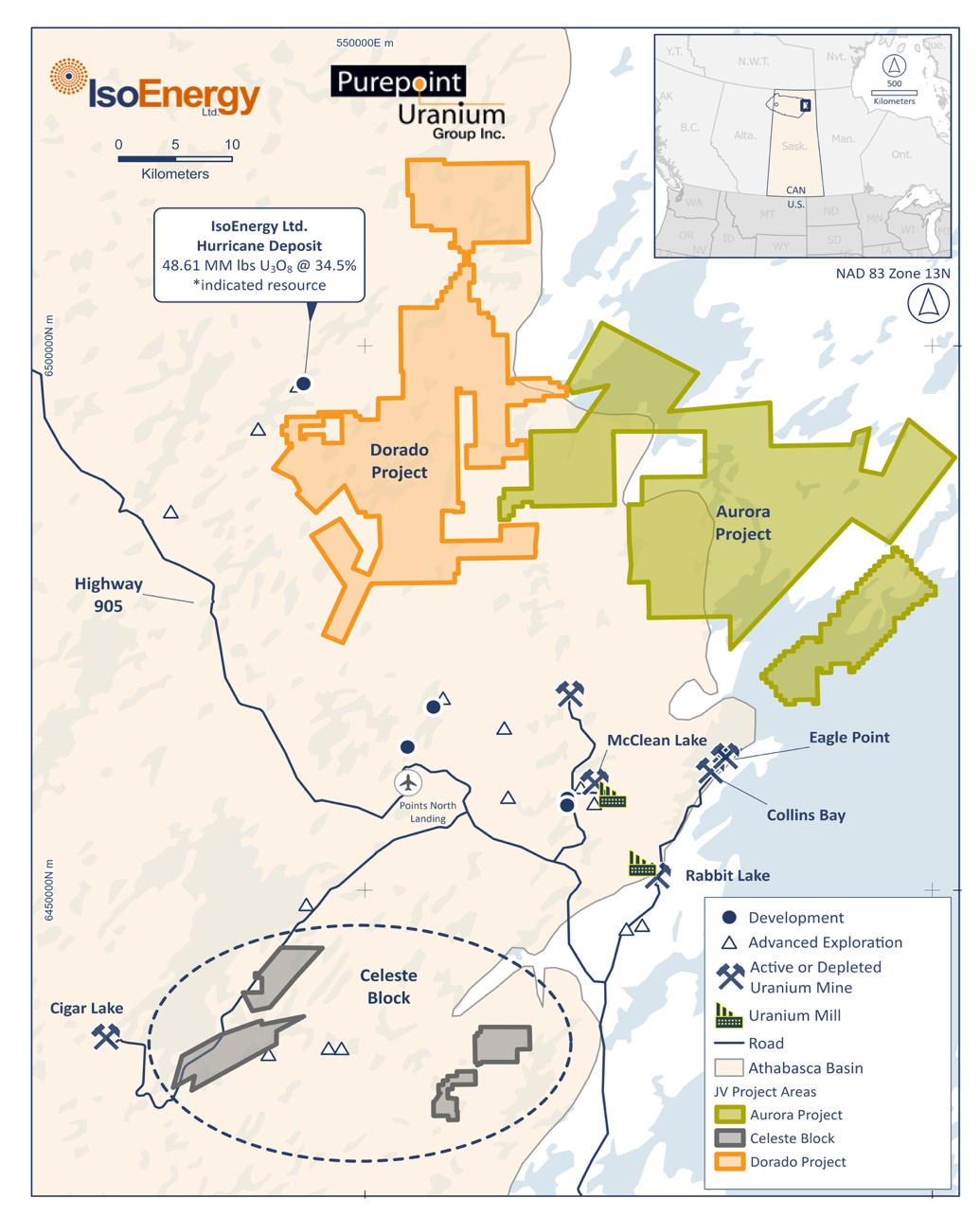
DORADO PROJECT
The Dorado Project brings together the Turnor Lake, Geiger, Edge, and most of the Full Moon properties into a single high-priority initiative along the Larocque Trend, which also hosts IsoEnergy’s Hurricane Deposit. Exploration will focus on graphitic conductors encircling a granitic dome, with a unified approach to historical geophysical and geological data across the combined area. The trend stretches 14 kilometres east of Hurricane, with drilling at Turnor Lake and Geiger revealing shallow unconformities (27–133 metres) and high-grade basement-hosted uranium, including 2.74% U3O8 over 1.2 metres in HL-50.
Drilling completed in 2025 delivered the Nova discovery, where the joint venture reported uranium grades up to 8.1% U3O8 over 0.4 metre within 2.1 metres of 1.6% U3O8 in hole PG25-07A, confirming a steeply dipping uranium-bearing structure that remains open in all directions.
The joint venture has approved a 2026 exploration program consisting of 17 drill holes totalling 7,450 metres across winter and summer campaigns. The Winter 2026 program (January–March) will focus on expanding Nova with 10 holes totalling approximately 4,300 metres, while the district-scale Summer 2026 campaign (July–August) will test priority targets with 7 holes totalling approximately 3,150 metres. An airborne magnetotellurics survey is planned for late winter or spring, and winter access and wetland drill pads will be established this month, including 8 km of existing trail and 10 km of new trail construction.
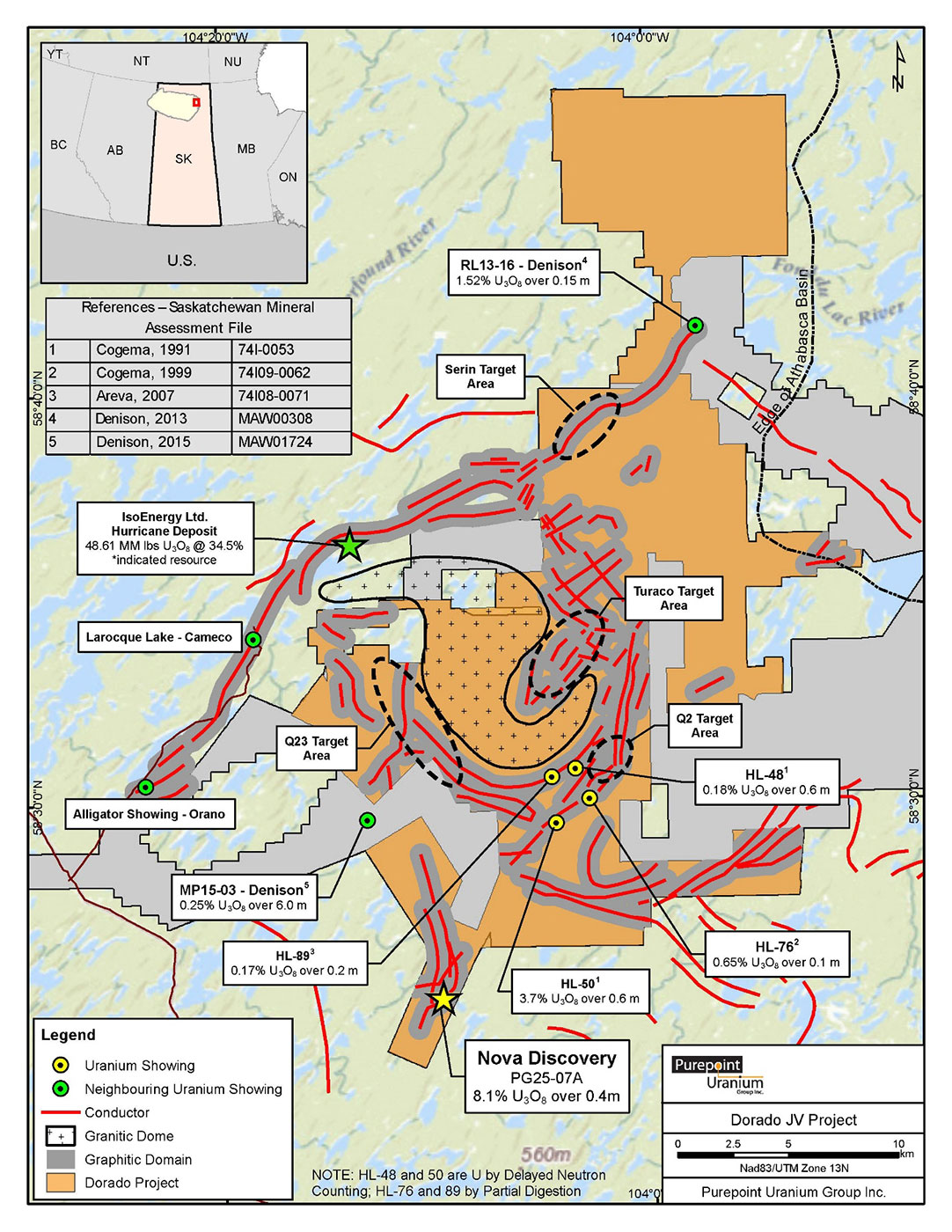
Dorado Joint Venture Project
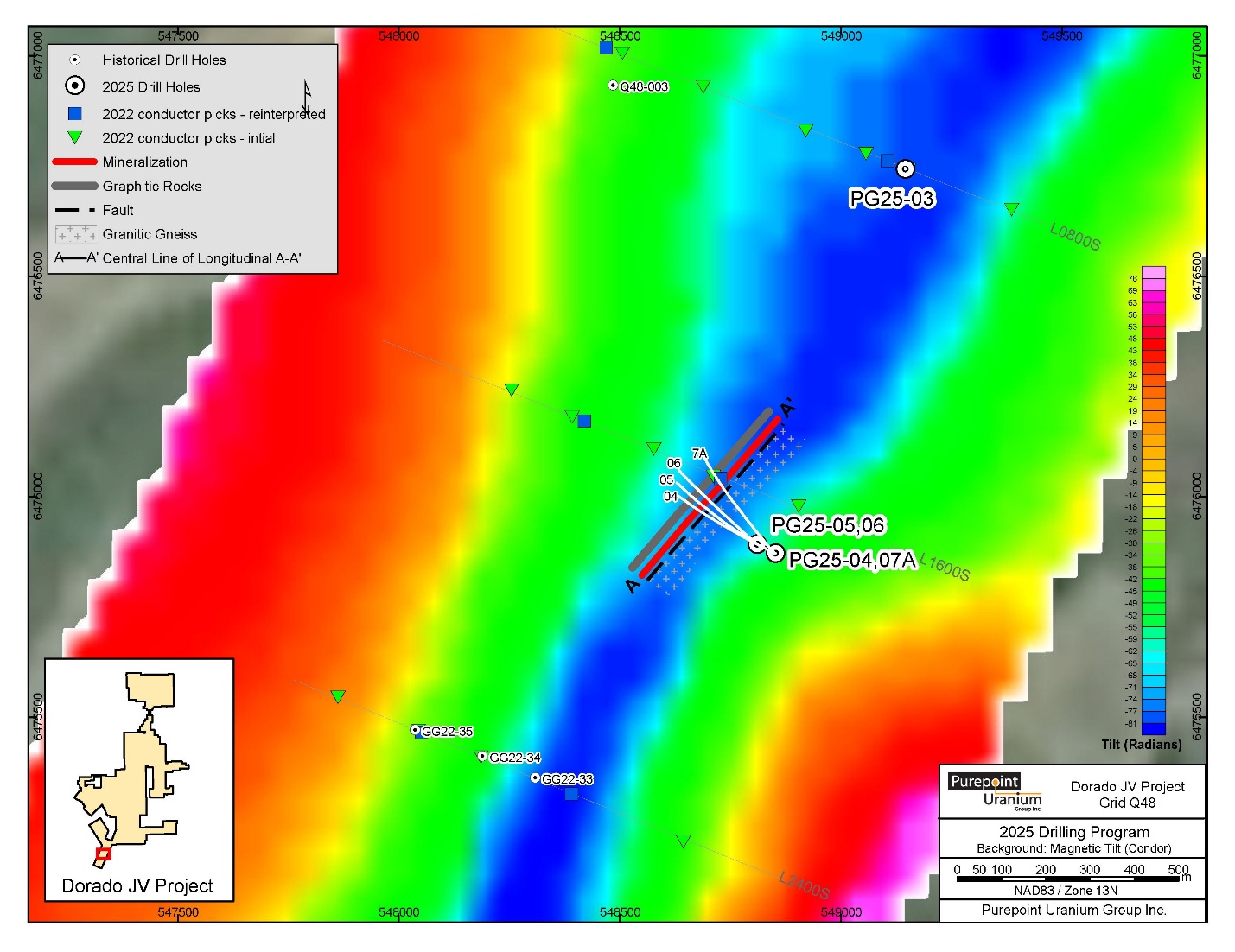
Location Map of 2025 Drill Program at Q48 Target Area and the new Nova Discovery
AURORA PROJECT
The Aurora Project includes the remaining claims east of Dorado, covering parts of Full Moon, Red Willow, and Collins Bay Extension. This area offers significant near-surface uranium potential in proximity to the McClean Lake mine and Rabbit Lake mine and mill.
CELESTE BLOCK
The Celeste Block encompasses the Thorburn, North Thorburn, Madison, and 2Z properties, which overlie conductor trends near the Cigar Lake Mine and southwest of the Rabbit Lake and McClean Lake operations. Sandstone cover is relatively shallow, ranging from 60 metres at Madison to 350 metres at Thorburn. Near-term efforts will concentrate on drill testing at Madison, where minimal historical drilling has occurred, with only one hole completed since 1989.
BULYEA RIVER PROJECT
The Bulyea River Project is an early-stage uranium exploration property located on the northern edge of the Athabasca Basin in Saskatchewan, Canada. It is characterized by very high uranium in lake sediment geochemistry and a strong airborne radiometric anomaly, indicating potential shallow basement-hosted uranium targets.
In 2024, IsoEnergy completed the acquisition of the property and began compiling existing data alongside airborne geophysics to refine exploration targets.
During 2025, the company advanced the project with the acquisition and processing of satellite hyperspectral survey data to improve geological understanding and guide follow-up fieldwork, including prospective geological mapping, sampling, and prospecting.
IsoEnergy’s planned work will continue to focus on translating these datasets into well-defined targets and preparing for ground geophysics and future drilling to test for uranium mineralization.
Bulyea River Geochem and geophysical signature
RADIO
IsoEnergy holds a 100%-interest in the Radio project in the eastern Athabasca Basin contiguous with Rio Tinto's Roughrider deposit (Rio Tinto bought Hathor Exploration in 2012 for C$654 million).
Before IsoEnergy, only one campaign of drilling had ever been completed on the Radio project. NexGen Energy drilled a total of nine holes (totaling 3,472.9 metres) during the summer of 2013 and identified clay alteration, structural disruption in the Athabasca sandstone and alteration and structures in the basement rocks. These features are known to occur at or in the vicinity of high-grade uranium mineralization in the Athabasca Basin.
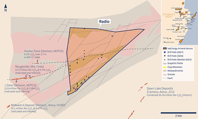
Radio Property Regional Magnetics and Target Areas
IsoEnergy has completed 23 drill holes totaling 8,859 metres in two campaigns in 2016 and 2017. Drilling targeted three east-west oriented magnetic lows on the property, including the Roughrider corridor that extends onto Radio from Rio Tinto’s Roughrider deposit, 2km to the west.
The drilling successfully located a large zone of strong basement hosted clay alteration in the southern magnetic low corridor. The zone is similar to the alteration zone surrounding the Roughrider deposit and is associated with strongly graphitic structures and locally elevated uranium and uranium pathfinder geochemistry.
CABLE
The Cable project is situated in the east-central portion of the Athabasca Basin. The project comprises ten contiguous claims and one non-contiguous claim covering 44,425 hectares with a vertical depth to the unconformity between 870 to 1,000 metres.
CARLSON CREEK
The Carlson Creek project is located 19 kilometres northeast of the McArthur River mine and five kilometres east of the Paul Bay, Ken-Pen, and Orora zones. Carlson Creek comprises one claim covering 759 hectares in the Key Lake – McArthur River – Cigar Lake corridor. The vertical depth to the unconformity is 410 to 460 metres.
EDGE
The Edge Project is located 19 kilometres northeast of the Hurricane zone and comprises 3 claims totaling 6,515 hectares. Drilling indicates the vertical depth to the unconformity is 40 metres.
LAROCQUE WEST
The Larocque West project is located 5 kilometres west of the Larocque Lake Zone, 10 kilometres southwest the Hurricane zone, and 35 kilometres northwest of McClean Lake mine. The project consists of 6 mineral claims totalling 509 hectares. The vertical depth to the unconformity is 335 metres.
MADISON
The Madison Project is located 14 kilometres east from the Sand Lake uranium deposit (1.3 metres at 22% U3O8) and only 7 kilometres west of Highway 905. The Madison property has seen 11 historic drill holes by Eldorado, Denison, and Cameco, with only one occurring after 1989. Sandstone cover is very thin at only 60 metres. The property comprises one claim covering 1,347 hectares.
WHITEWATER
The Whitewater Project is located 32 kilometres northwest of Stony Rapids and 15 kilometres northeast of the Athabasca Basin. The property comprises 5 claims totalling 7,833 hectares and covering 11 km of the Grease River Shear.
